Category Archives: 2020

Pingo Parade: The Last Observations of the Dawn mission to Ceres

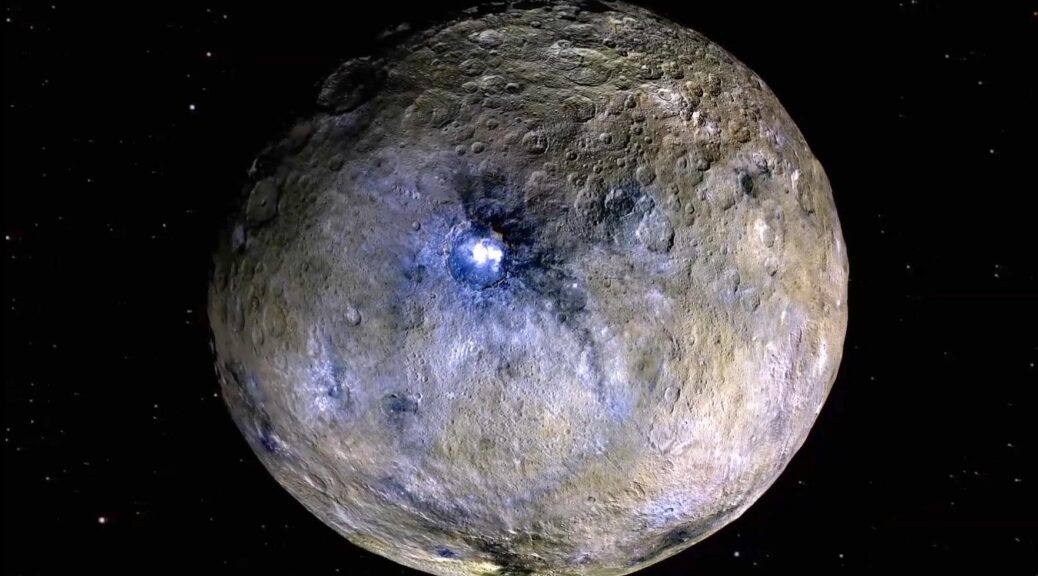
Tantalizing evidence shows the dwarf planet bears striking similarities with Earth and Mars

Members of the Planetary Habitability & Technology lab at Georgia Tech are the authors of one of several new and exciting papers about dwarf planet Ceres. The paper is one of seven based on data from NASA’s Dawn mission, and suggests that Ceres has pingo-like formations that share characteristics with those on Earth and Mars.

Pingos are dome-shaped hills, which on Earth form in areas where the ground remains partially frozen year-round. Similar to how a bottle of soda in the freezer will push off its cap and expand up out of the bottle as it freezes, when groundwater freezes, that pressure can push up a layer of the ground to form a dome-shaped hill called a pingo. These pingos can continue to grow for hundreds or thousands of years — as long as water continues to flow to the near-surface, that water will freeze and the pingo will grow.

a) Oblique view of the ~50 m tall Ibyuk Pingo, Tuktoyaktuk, Northwest Territories, Canada (image credit - CBC). (b) Plan view look at Ibyuk Pingo (image credit - Google Earth). (c) Pingo candidate on Mars (image credit NASA/JPL/UA/MRO/HiRISE). (d) Two pingo candidates on Ceres (image citation NASA/JPL/Dawn)
a) Oblique view of the ~50 m tall Ibyuk Pingo, Tuktoyaktuk, Northwest Territories, Canada (image credit – CBC). (b) A look at Ibyuk Pingo as seen from directly above (image credit – Google Earth). (c) Pingo candidate on Mars (image credit NASA/JPL/UA/MRO/HiRISE). (d) Two pingo candidates on Ceres (image citation NASA/JPL/Dawn)

“For years I’ve been strangely obsessed with Pingos. My advisor in grad school assigned us a paper on them and I’ve been thinking about them ever since. When it came time to propose ideas for Dawn to investigate, both Hanna and I proposed that we should search for pingo-like features on Ceres. There were hints in the early data, but it took the resolution of the XM2 (Second extended mission) phase of the mission to finally have enough resolution to really make a strong case that this kind of feature can form on Ceres,” said Georgia Institute of Technology associate professor Britney Schmidt, one of the paper’s authors.

The paper, published in Nature Geoscience, points to parallels in the pingo-like hills on Ceres and pingos on Earth, making a strong case for there being similar geologic processes causing both. Data the team analyzed from the Dawn mission suggests the Ceres hills are rich in water, with similar size and distribution to Earth’s pingos.

“The combination of morphology (shape), distribution, clustering behavior, association with water-rich materials, and young apparent age, in our analysis, made an extremely compelling case for these features to be ice-cored hills like pingos on Earth,” said Kynan Hughson, one of the paper’s authors and a postdoctoral fellow working with Schmidt. Hughson and Schmidt along with Hanna Sizemore of the Planetary Science Institute were the lead investigators for the study. “We also found that they cluster and organize in ways similar to terrestrial pingos.”

Comparison of a possible pingo candidate on Ceres (a: image credit NASA/JPL/Dawn) with Ibyuk Pingo (b: image credit ESA). While the cerean mound is nearly twice as large in every dimension, their forms are similar (c). Profiles were derived from Dawn stereo pairs and the ArcticDEM (Porter et al., 2018)

A possible pingo candidate on Ceres in perspective.
Perspective views of two pingo candidates in Occator crater, shown as Figure 4 in the new paper in Nature geoscience by Schmidt et al. Credit: Kynan Hughson/Georgia Tech/NASA/MPS/DLR

Ceres is the 25th largest body in our solar system. The dwarf planet is also the largest asteroid (roughly as wide as the state of Texas), located in the asteroid belt between the orbits of Mars and Jupiter, even larger than Saturn’s famous moon Enceladus. The Dawn spacecraft circled Ceres from 2015-2018, and was able to collect data from just 35 km above the surface in its final phase before running out of fuel. Its focus in the XM2 mission was Occator crater — a 20-million-year-old impact crater with interesting characteristics.

Occator contains the brightest cluster of spots observed on Ceres, with a bright dome in the center. Early in the mission these bright spots in Occator were speculated to be deposits from brines — water with a high concentration of salts —XM2 confirmed this, and revealed ways that these brines come from below the surface of the dwarf planet.

In their Nature Geoscience publication, Schmidt, Hughson, Georgia Tech undergraduates Kayla Duarte, Vivian Romero and Kathrine Udell, and Dawn mission colleagues wrote about how the hills in Occator crater may have formed from refreezing of subsurface flowing water, produced by melting by the impact that formed the crater. Their work suggests that the effects that happen when groundwater refreezes, dubbed “cryo-hydrologic processes” in the paper, were active on Ceres in the recent geologic past, similar to how pingos form on Earth and potentially even Mars.

Topographic perspective views of the the central dome Ceralia Facula in Ceres’ Occator crater, from figure 1a of Schmidt et al 2020. Ceralia Facula and other hills and mounds on Ceres are reminiscent of pingos on Earth. Credit: Kynan Hughson/Georgia Tech/NASA/MPS/DLR

“On Earth, seasonal cycles in permafrost affect the growth and survival of pingos. In fact, the warming conditions we’re seeing right now in the Arctic due to climate change have caused pingos to collapse and even explode”, Schmidt said. “There aren’t any cycles like this on Ceres, but we know the floor of Occator was full of liquid water and brines from the impact, which would have frozen at the surface but allowed the subsurface liquid to remain for many, many years. In that case, any differences in pressure or porosity in the ground would allow these cryo-hydrologic processes to mimic how pingos form on Earth.”

Ceres is a C-type asteroid, which are among the oldest and darkest asteroids in our solar system. This type of asteroid rained down on the early Earth, bringing with them water and other important ingredients for life, Schmidt explained. In the series of 7 papers coming out in the Nature family of journals celebrating Dawn’s XM2 mission, Schmidt, Hughson, and other contributors show that these water-rich small bodies like Ceres still exist in the inner solar system. Schmidt is a co-author on the two Nature Communications papers led by Paul Schenk of LPI in Houston and JPL’s Jennifer Scully, on which the undergraduate team lead by Duarte are also co-authors. Hughson and Schmidt are both co-authors on the paper reporting ice deep in Ceres’ crust led by Ryan Park of JPL.

In the future, NASA hopes to use probes to explore the surfaces of icy planets and asteroids like Ceres, Europa, and others, and Schmidt and Hughson both hope for a return to Ceres in the near future.

“Sampling and analyzing the rock and ice on the surface of Ceres, as well as confirming the icy nature of these mounds in the future, will help inform us of Ceres’ past and present habitability. This will also inform us of rock weathering processes that take place within the interiors of icy moons like Europa and Enceladus, and shed light on the origin of Earth’s water,” Hughson said.

Pingos in the Arctic, water on Mars, climate change, and astronauts

In addition to identifying pingo-like formations on Ceres, Schmidt and Hughson are working to understand Earth’s pingos even better, which will improve our understanding and study of similar formations elsewhere in our solar system like Mars and Ceres.

“Like on other planetary bodies, cryo-hydrologic processes are altering the landscape here on Earth as well, dropping an incredible opportunity into our lap. With PingoSTARR, we’re going to head north and survey pingos with our best geophysical tools, so that we can start to put numbers on the formation and collapse processes govern the ‘lifecycle’ of pingos. With any luck, we’ll come back with a better understanding of ground ice processes that govern change on not just the Arctic coastline, but also beneath ice sheets and across other planetary bodies,” said Matthew Siegfried, another of Pingo STARR’s primary investigators.

The Planetary Habitability & Technology team just received a $2 million grant called Pingo STARR: Pingo SubTerranean Aquifer Reconnaissance & Reconstruction from NASA to bring together the best techniques to explore pingos on Earth as a steppingstone for looking for water on Mars and Ceres that could one day be used by astronauts. While they’re at it, they’ll also be helping understand the effects of climate change.

“Full 3D characterization of pingos and their surrounding/underlying hydrology has not been done. Filling in this knowledge gap not only teaches us more about these Arctic oddities and processes that govern them on Earth, but allows us to construct more detailed and testable hypotheses about how pingo analogs might form in the solar system,” Hughson said.

Mackenzie Delta, Pingo, Tuktoyaktuk. Detail of pingo in the Mackenzie Delta with massive injection ice. Photo: Lorenz King, JLU Giessen.de, August 8, 1987
Detail of pingo in the Mackenzie Delta with massive injection ice. Photo: Lorenz King, JLU Giessen.de, August 8, 1987

Their team, along with colleagues from the Colorado School of Mines and the Planetary Science Institute, are looking forward to extensive research in the arctic in order to “detect, characterize, understand, and eventually utilize groundwater and ground ice deposits on worlds such as Mars and Ceres,” Hughson said.

Another important reason for studying pingos on Earth is that these hills can be “important recorders of climate history.” Over the next four years, the team will use a combination of geophysical techniques—things like radar and electrical conductivity that can be used to map subsurface water and ice—to explore pingos on the north slope of Alaska and Canada’s pingo-dotted Tuktoyaktuk peninsula where some of the world’s largest and most densely clustered pingos are found.  These are some of the best analogs for pingos-like features on other planets, but are also indicators of what’s happening on Earth due to climate change.

“Their size and texture tell us about recent changes in the Arctic,” Hughson said. “By observing and characterizing their ice structure using geophysical methods over several years we will be able to identify rapid changes in ice saturated permafrost.”

“There have been a lot of papers trying to understand whether features on other planets really are pingos, and if so, what that says about the subsurface conditions on these planets. With the Pingo STARR project, we’ll help uncover the plumbing of these features and better understand what they say about how water, ice, and time affect the surfaces of planets, including our own,” Schmidt said.

We can’t Th(wait)es to answer your FAQ about Thwaites and Icefin!

Thwaites FAQ: On May 21, 2020, PI and Icefin Lead Scientist Dr. Britney Schmidt participated in a Twitter Q&A session with Bulletin of the Atomic Scientists, and answered some of your most frequently asked questions about Thwaites and Icefin as part of the #ThwaitesGlacierChat. If you’re new to Thwaites and/or Icefin, this is a great place to start! If you’ve been following us for a while, here’s your chance for a more in-depth understanding of what we do, and why it matters.

Bulletin Atomic: The International Thwaites Glacier Collaboration is a 5-year project involving a huge number of scientists, ships, and aircraft to study the Antarctic. Why is this research important? What are you hoping to find?

Dr. Schmidt: Thwaites Glacier is one of the fastest changing glaciers in Antarctica. We want to understand how that works, and how quickly climate change is affecting the glacier. One of the ways to do this is to make measurements up close and personal with the processes affecting the ice, like melting from the warming ocean. 

Bulletin Atomic: What is the difference between sea ice and the ice on land? Do they each contribute to sea-level rise?

Dr. Schmidt: Ice on land (glaciers) is formed from compacting snow, but sea ice forms from ocean freezing. Glaciers like Thwaites enter the ocean below sea level. What this means is that glaciers can be easily affected (melting) by the ocean, and when they speed up, they add ice and water to the ocean, changing sea level. So the melting of sea ice can cause more glacier melting, through warming of the ocean, which means sea level rise. While sea ice doesn’t change sea level, as it melts, the bright ice that reflects sunlight is replaced by dark ocean that absorbs heat, which accelerates ocean warming.

Bulletin Atomic: MELT Project is part of the International Thwaites Glacier Collaboration. What is that project and how does it fit into the overall effort to understand the Thwaites Glacier?

Dr. Schmidt: With MELT, we’re getting up close and personal with the place where sea level rise starts for glaciers like Thwaites — the grounding zone. Icefin used a hot water drilled hole, [drilled] by British Antarctic Survey team Hot Water On Ice, to get under the 600m of ice and swim 2km back to where the glacier starts to float on the ocean (the grounding zone).

Bulletin Atomic: Is the Antarctic melting? All of it? And how do we know?

Dr. Schmidt: Quite a lot of melt is happening. We got to see it happening every time we went under the ice at Thwaites Glacier, a lot of which you can see in this video from Icefin here. Here’s our favorite image Icefin took of the grounding zone from under Thwaites, but there are lots more here

An Image Icefin took of the grounding zone from under Thwaites.

Bulletin Atomic: We’re tweeting an image from Peter Davis’ trip of the first borehole that was drilled. What are we looking at, and what does it tell your team? (Image credit: Screenshot of borehole trip video from Peter Davis, available here, as seen below)

Screenshot of borehole trip video from Peter Davis.

Dr. Schmidt: Icefin went down this 600m hole 5 times, drove about 15km total, and mapped the base of the ice, tasted the water, and measured melting — plus we found some cool organisms! When we got this video back from the Hot Water On Ice team, we knew it was safe to put Icefin and the other science instruments through the hole to start science.

Bulletin Atomic: Are there instruments left in place at Thwaites Glacier? Are you getting real-time readouts or does someone have to go back to collect the instruments and data?

Dr. Schmidt: Lots of the teams have left instruments to measure change and monitor conditions on Thwaites Glacier over the next few years. MELT has GPS stations and tilt meters and ApRes that Hot Water On Ice and glaciologist Kiya Riverman and others will be working with, and a team will go back out to retrieve the instruments. The Icefin team is back remote-sciencing at the Georgia Tech College of Sciences and Georgia Tech School of Earth and Atmospheric Sciences, working on all the data from last year. Looking forward to getting papers out soon!

Bulletin Atomic: What will the melting of Thwaites Glacier and other parts of the Antarctic mean for sea level rise? How long will it take, and how high will it go

Dr. Schmidt: Thwaites Glacier is in a precarious position, like the Atlas of West Antarctica, holding back a deep basin of ice that supports the whole ice sheet. If Thwaites Glacier goes, there will be much faster loss of ice and sea level rise. We don’t know exactly how fast Thwaites Glacier is responding to climate change, which is why the National Science Foundation and Natural Environment Research Council put together the International Thwaites Glacier Collaboration, because we have to find out.

Bulletin Atomic: What stands out about working in such a remote area? As the technology improves, how will it help future researchers study the glacier?

Dr. Schmidt: Working on Thwaites Glacier was incredibly humbling and exciting. Antarctica is one of the few places that just knocks you back off your feet when you see it. Technology is definitely improving, helping us see new things, but the people doing the work mean even more.  Science is a human endeavor, and a moral imperative. But sometimes you do get to drive robots under the ice, which is pretty cool.

From our perspective, using technology that NASA funded us to build to one day get to Europa, has helped us see our own planet in new ways. Icefin lets us see, “taste”, and “touch” the processes as they happen, swimming the instruments right up to where the action is, which is a new way to understand the ocean and the ice. And it’s pretty cool, because we can add those measurements over a mile away from the bore hole to seismic data from Kiya Riverman and ocean and radar data from Hot Water On Ice, and we get a new picture of how melting at the ice base is happening. Then you add together the work being done by MELT to the science from THOR, TARSAN, GHOST, DOMINOS, GHC, TIME and PROPHET and the whole Thwaites Glacier team can help us really know what’s happening now and what will happen next.

We may be social distancing, but the Icefin team is still #RemoteSciencing

It’s an unprecedented time for everyone, including the scientists and engineers who work on Icefin. Being away from our labs and workstations means the Icefin team members have to get creative with remote-sciencing to keep things moving forward in the time of Covid-19.

For some, that means engineering complex electronics on a fold-out table, for others it’s meant commandeering the living room or front porch for a quiet place to concentrate on data analysis and research. Wherever our team members are social distancing, we’re still remote-sciencing. Here’s what that looks like… multimeters, kiddie pools, computers, cats, and all!

Icefin’s Lead Electrical Engineer Daniel Dichek has been working on building and testing battery hardware on his home workbench.

Working on building and testing battery hardware

Postdoc and NASA Postdoctoral Program Fellow, Icefin’s Andy Mullen has been working in his home electronics lab setup. “I’ve been working on the software and electronics for a custom underwater microscopic imaging system for observing microbes in the ocean aboard Icefin. The internal components and underwater housings of the microscope are on the blue mat on the table,” he said.

Postdoc and NASA Postdoctoral Program Fellow, Icefin’s Andy Mullen has been working in his home electronics lab setup. "I've been working on the software and electronics for a custom underwater microscopic imaging system for observing microbes in the ocean aboard Icefin. The internal components and underwater housings of the microscope are on the blue mat on the table,” he said.

Along with working on the microscope itself, when the microscope needed a stand, Andy got creative while working from home and made one for it using LEGOS. He already had some at the house and they worked perfect!

He’s also been doing some 3D printing from home. “I have been making a manifold to route water for the custom water sampler that is being developed for Icefin.” These are pictures of the manifold at different stages of its fabrication: an empty 3D printer, the finished manifold still in the 3D printer, showing the manifold’s internal channels by holding it up to the sun, tapping the manifold holes, the manifold done with solenoids attached.

Graduate Student and Icefin Engineer Ben Hurwitz enjoyed working outside on his patio, complete with a kiddie pool, on a beautiful 85°F day in Atlanta.

Graduate Student and Icefin Engineer Ben Hurwitz enjoyed working outside on his patio, complete with a kiddie pool, on a beautiful 85°F day in Atlanta.

Icefin Primary Investigator and Lead Scientist Dr. Britney Schmidt has a purrrfect home office setup, can you spot the cat?

Frances Bryson is working on sampling systems for under ice environments, for both Icefin and VERNE projects. The arm here is a basic prototype Frances is using to act as a proof of concept and test out software and controls for a version that will eventually go on Icefin.

Research Engineer Anthony Spears has no shortage of screens in his home remote-sciencing setup!

Research Engineer Anthony Spears has no shortage of screens in his home remote-sciencing setup!

During social distancing, Research Scientist Peter Washam is looking into ocean circulation data from beneath Thwaites Glacier and Ross Ice Shelf, near the grounding line of Kamb Ice Stream. “The flow beneath in the ocean cavity beneath these two large bodies of ice is very different, with tides primarily moving water in an elliptical motion beneath Ross and freshwater production from melting apparently driving the circulation beneath Thwaites,” he said.

During social distancing, Research Scientist Peter Washam is looking into ocean circulation data from beneath Thwaites Glacier and Ross Ice Shelf, near the grounding line of Kamb Ice Stream. “The flow beneath in the ocean cavity beneath these two large bodies of ice is very different, with tides primarily moving water in an elliptical motion beneath Ross and freshwater production from melting apparently driving the circulation beneath Thwaites,” he said.

Graduate Student and Icefin Scientist Justin Lawrence is using Icefin’s custom data visualization dashboard to look at water column temperature and salinity under the Ross Ice Shelf.

Graduate Student and Icefin Scientist Justin Lawrence is using Icefin’s custom data visualization dashboard to look at water column temperature and salinity under the Ross Ice Shelf.