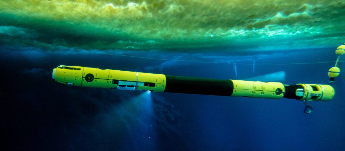
We’re excited to announce that as part of the MELT team and the International Thwaites Glacier Collaboration (ITGC) between the U.S.’s National Science Foundation (NSF) and the U.K.’s Natural Environment Research Council (NERC), we’ve been funded to send Icefin to look at the underside of the Thwaites glacier in the 2019 field season! This is an extremely important effort to look at one of the fastest changing regions in Antarctica and will be critical to informing our understanding of global climate systems- we’re excited to be part of such a large and capable international team undertaking this work.
Read on and see the official press releases from NSF, NERC, and Georgia Tech for more details, and there’s some great videos as well on our Facebook page as well- check them out!

What is Thwaites?
Thwaites glacier is on the left side of this map, midway between the Ross Ice Shelf (bottom large blue/purple section) and the Peninsula (top-left pointy bit). The plot shows the velocity of the ice flows across Antarctica – notice how red Thwaites is. McMurdo, for comparison (though not shown) is off the Ross Ice Shelf, midway between Byrd and David glaciers. (Credit: E. Rignot, et al. “Ice Flow of the Antarctic Ice Sheet,” Science, Vol. 333, No. 6048, p.1427-1430, 2011.)
Thwaites is a massive glacier on the West Antarctic ice sheet. It is approximately the size of Florida and accounts for nearly 4% of global sea level rise, a contribution that has doubled since the 1990s. It also happens to be more than 1000 miles (1600 km) from the nearest permanent station, so getting there is extremely difficult, even by Antarctic standards. Due to these difficulties, we know very little about this enormous ice mass, which is a significant issue for global climate studies as a collapse could significantly raise global sea levels.
What is MELT?
MELT, “Melting at Thwaites grounding zone and its control on sea level“, is an interdisciplinary collaborative project between five universities and the British Antarctic Survey (BAS) that aims to use autonomous sensors, vehicles (including Icefin), radar, and moorings to monitor the Thwaites ice shelf and grounding line. The goal is to better understand how the ice is flowing, ice-ocean interface dynamics, and the ocean bathymetry (i.e. the sea floor) in this region, with a particular focus on melting rates and dynamics. Hot water drills will be used to make small holes in the shelf so Icefin can access the ocean and grounding zone underneath, as well as for placement of the ocean moorings and autonomous sensors that will monitor year-round for the duration of the project.
This data will then be used to augment state-of-the-art ocean and ice sheet models for better understanding of how this highly dynamic and sensitive system interacts with global climate cycles so we can better estimate the state of the glacial basin over the coming centuries. For more information, check out the project page here.
The project is lead by Dr. Keith Nicholls, an oceanographer with the British Antarctic Survey (BAS), and Dr. David Holland, an applied mathematician (with a background in fluid dynamics) at New York University, with co-leads Dr. Eric Rignot from the University of California at Irving, Dr. John Paden with George Mason University, Dr. Sridhar Anandakrishnan out of Pennsylvania State University, and our own Dr. Britney Schmidt.
What is the ITGC?

The International Thwaites Glacier Collaboration (ITGC) is a $25 million international research collaboration between the U.S. and U.K. through their two major Antarctica research organizations, the National Science Foundation (NSF) and the National Environmental Research Council (NERC), respectively, to send scientists to the Thwaites glacier region to collect data on how the glacier is current doing, when a collapse might occur, and how that would affect global sea levels and global climate. There are eight separate projects being funded with over 100 scientists from seven different countries, so it’s a massive collaborative effort and the largest between the U.S. and the U.K. in Antarctica in more than 70 years. Teams will deploy submersibles, radars, planes, drills, remote sensing stations, seismometers, ships, ocean gliders, and all kinds of other advanced technology to do this research over the coming five years.

If you’d like to know more, here are a few other links:
The official press release from the British Antarctic Survey (BAS)
A very cool GIF of the Thwaites glacier calving icebergs, courtesy of Dr. Noel Gourmelen (via CPOM News on Twitter)
You can also hunt down more information on Twitter with the hashtag #ThwaitesGlacier and the handle @ThwaitesGlacier.

